Anyone in the northeastern U.S. who’s “dreaming of a white Christmas” has a disappointing awakening coming. High temperatures 10 to 30 degrees above normal in the entire eastern half of the country could allow rain, but no snow. This pattern’s similar to what climate scientists predicted for this year in the wake of possibly the strongest El Niño event recorded.
[caption id="attachment_19705" align="alignright" width="300"]
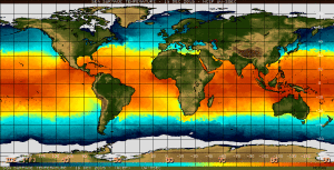
Sea surface temperature - via NOAA[/caption]
Trade winds usually pile warm surface water on the western side of the Pacific, off the coast of Indonesia. During an El Niño year, trade winds fail and that warm water sloshes back to the west coast of South America. Right now, the water there is more than two degrees warmer than average. The warmer water and atmosphere during an El Niño typically can lead to major changes in weather patterns in the U.S. and across the world,
according to the National Weather Service.
El Niño patterns are usually
strongest from December to March. Let’s look at what El Niño could mean for some other parts of the U.S. We considered California on December 3.
Pacific Northwest
National Weather Service maps give a high probability that the Pacific Northwest will be normal than usual and a chance that it will be drier than usual.
This has worried northwestern water managers who in April measured record-low snow levels in
parts of the Cascade Mountains. It also worried emergency managers, who saw more than a million acres of
forest burn during the spring and summer.
So far, they needn’t have worried. The area has been hammered by one major storm after another.
Floods have engulfed the Oregon and Washington coasts. The Mt. Baker, Wash. ski area
has 190 inches of snow. Last year at this time it had
six inches. One atmospheric scientist called it a “
La Niña type phenomenon.”
That doesn’t mean things can’t change. The Pacific Northwest
usually dries out in the latter part of the winter.
Southeast
The Gulf Coast and southeastern U.S. have
historically been colder and wetter during strong El Niño years.
So far, the southeast has seen warmer-than-normal temperatures but lots of rain and flooding. Texas had its
fifth wettest October recorded. As of mid-November, Atlanta had
more than a foot above average in rainfall for the year.
Later winter could include
ice storms in the Deep South.
[caption id="attachment_19707" align="alignright" width="300"]
via NOAA[/caption]
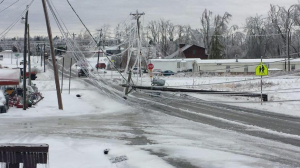
Ice storms can have nasty results. One that struck Tennessee at the end of February brought down trees and power lines all over areas east of Nashville. At the height of the storm, the whole of Fentress County and part of Cumberland County – 35,000 people – were without power, according to a NOAA report. Some didn’t get it back until March. Cumberland County Emergency Management called it the “worst natural disaster in the history of Cumberland County.”
Strong El Niño events tend to reduce the number of Atlantic hurricanes. However, severe thunderstorms and tornadoes can become
more common in central and southern Florida. On February 22, 1998, during the strongest El Niño year recorded, seven tornadoes struck central Florida. Forty-two people were killed.
So far, the south’s weather has been unusually warm.
Forecast high temperatures for the week of Christmas are between 10 and 20 degrees higher than normal.
Northeast
After January and February brought
record-breaking snow and cold temperatures to the northeast, people there may Replace a white Christmas kind of anathema. That’s good, because December is shaping up to be the warmest in memory. Buffalo, N.Y.
broke a 116-year record for the latest date with no snow on the ground.
The rest of the winter season will likely be warmer than normal too. However, that doesn’t mean warm. A temperature a few degrees warmer than normal
means ice storms rather than snow storms. One of the worst ice storms in history took place in the northeast U.S. and Canada January 5-8, 1998, during the last strong El Niño. Forty-four people were killed,
more than 500,000 people lost power and damage totaled $4.4 billion in the U.S. and Canada.
All these forecasts are maybes. Yes, this year U.S. weather seems to be following a
classic strong El Niño pattern. But even strong El Niño patterns have variations.
One climate blogger compared it to a bartender who occasionally messes up a drink order.
“Sometimes El Niño is the bartender who doesn’t bring you what you ordered,”
he said.
So if the threat of abnormal El Niño weather spurs you to prepare, great.
Ready.gov has information about El Niño preparation.
The National Weather Service and weather.com have El Niño information. Check it out, then plan for your area. And be ready for something else.
There's your El Niño national outlook. How is El Niño treating you in your neck of the woods?
1 comment
gary bengtson
What about the southwest U.S.?